Showing posts with label Maps. Show all posts

Thursday, February 11, 2016

Post-Cruise: Dos Ojos Cenotes & Akamal

When Hubby and I first saw this Princess excursion being offered (for the first time), we knew it was a no-brainer decision to try it out.  We are adventurous and enjoy doing something different each time we visit an island.

In Cozumel, we've power boated over to Passion Island and enjoyed the white sand beach and some rest and relaxation.  We've snorkeled the Planacar Reef twice.  We've enjoyed beach time and laying in the hammocks at Playa Mia beach resort.  We've also enjoyed hanging out at the Puerta Maya cruise terminal dining at Panchos Backyard, shopping, and people watching.  

This new Princess excursion had me curious.  The trip included visiting a "cenotes" and then swimming with the turtles.  There were lots of questions from curious folks (like me), but no feedback from fellow Princess cruisers.  I did some research and found some maps.  Hmmmmm...there are a lot of "cenotes" in Mexico.  Which one would we be going to?  My inquiring mind wanted to know.  Where would we be swimming with the turtles?  

Now that we're back from our wonderful and awesome cruise, I can look on the map and say "we've been there!"

In the following map, we travelled south from Playa de Carmen (not on the map, but north of Puerto Aventuros) to Dos Ojos (just northwest of Tulum).  The main road that we travelled on is Mex 307.  Depending on what map I'm looking at, I can see 9-10 cenotes between Playa de Carmen and Tulum.  


Here's a map of the Dos Ojos Cenotes park.  Interesting, huh?


Here's a better map that show the blue turquoise fresh water system of Dos Ojos.  We started our practice swim/snorkel exercise in the 1st eye (primero ojo) and then got out and walked over to the 2nd eye (segundo ojo) and snorkeled to the bat cave:


When we were finished snorkeling at Dos Ojos, we travelled north to Akamal (see map above).  We entered the water off the beach near the Akamal Dive Shop area and snorkeled for some distance til we ended up near Akamal Beach Resort:


Here's a view looking from Akumal Beach Resort:


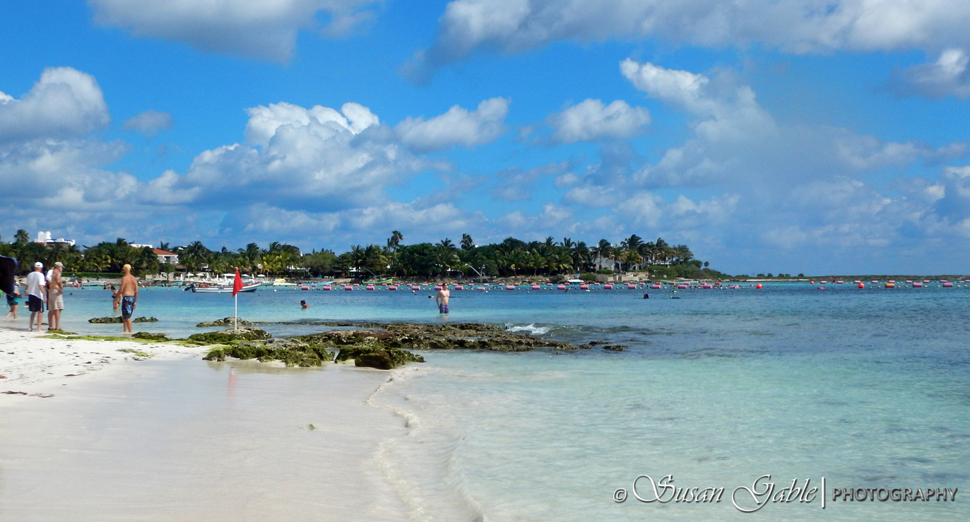
Hubby and I did not think we were snorkeling for that long or gone far.  When we are in the water seeing all the wonderful and beautiful marine life, we lose track of time.  Sometimes I would pop my head up and wonder where everyone had gone.  Yes, between Hubby and I, one of us will get called out for snorkeling away from the group.  We can't help it, we like following the marine life versus people.  ðŸ˜Š

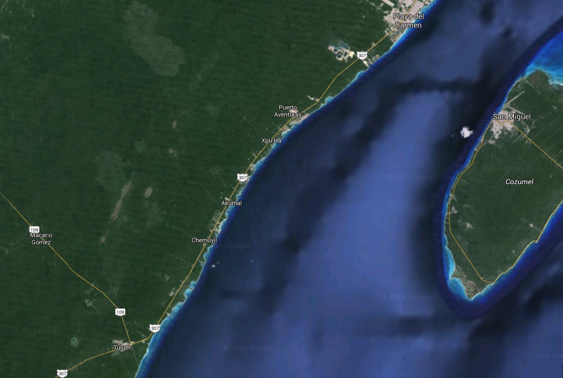
Here's a Google map that shows part of the island of Cozumel and the mainland.  Do you see the white cloud in the water?  That's close to where the Puerta Maya pier is located and where the Regal Princess docked.


For additional pictures, please see my recent posts for Cozumel.  

Wednesday, February 10, 2016

Post-Cruise: Costa Maya

Hubby and I had great time in Costa Maya.  We especially enjoyed our time at Blue Kay and hope to go back on our next cruise.  We also hope to do additional exploring of the Malecon beach area.

Here's a Google map to give you an idea of where everything is located:


In the upper right corner is the pier going out into the water where the Regal Princess docked.  The other end of the pier ends at the Cruise port or terminal.  We walked out of the 2nd exit (cruise terminal) and walked along a street until we reached a taxi stand on the right side of the road.  The taxi took us to the first roundabout where we made the 2nd left and continued to the next roundabout and made another 2nd left until we came to the end of the road.  Turned left and headed towards the lighthouse.  Just before the lighthouse we made a right and next left into Blue Kay's parking area and the start of the Malecon.

In case we forgot what Blue Kay looked like:


When we were ready to leave the beach, the folks at Blue Kay escorted us to an area where the cabs were waiting to take folks back to the cruise port/terminal.  

Monday, January 18, 2016

Monday-Day 9: Princess Cays

(Warning:  this a picture intensive blog post.  Pictures may be of lower quality...as in Point & Shoot.  Taken with Nikon AW-130).

I have an announcement to make:  I'm feeling so much better!  I have the last bits of antibiotics to take and it's been working like a charm!  I am so thrilled to get rid of that nasty congestion/coughing.  A big thank you to Dr Ranier on the Regal.  Now we can resume our regularly scheduled blogging post.

We were waiting for the sun to come out and then decided at the last minute to go ashore.  We headed down to deck 6 to get tender tickets.  We were the last two on the gangway to be scanned.  Nothing happened.  No "gong" sound to acknowledge us.  I heard a crew member yell to the tender captain to hold the tender for us.  The security personnel had to manually scan by looking up our stateroom number.  I saw our two mugshots appear on the screen.  Security approved us.  For 30 seconds I felt like a scolded child.  Then we entered the tender and set a course for Princess Cays.

The 8 minute ride was not bad except for the last 1/4 mile when the tender started to rock and roll.  Pretty neat feeling.   We were dropped off at the Princess dock and proceeded to the right towards South Beach.  That's when the sun came out in full force.  


There are two beaches here with the dock/pier being the dividing point:  North and South Beach.  North Beach is the larger of the two which also translates into crowded areas and long lines for lunch.  So South Beach made the most sense today.  I was able to capture a few shots of the Regal anchored in the water:  


A BBQ lunch was being served at the beach along with some food and beverage trucks.  


I think folks waited on the ship and then went ashore for the beach lunch.  We walked from one end of South beach to other end of North.  Here, we came across the cute cabanas: 


Each cabana has indoor furniture and storage areas to put personal things away.  I also saw an A/C unit for those really blazing hot days.  There are also colorful shops to purchase suntan lotions and snorkel gear and beach wear:


We came across a private residence.  Princess has a "caretaker" who lives on their island and oversees the maintenance and upkeep.  I think they do a great job:


A map in case we get lost....


Where's Hubby?


Where should weigh next?


After seeing all that we could on the beach and melting from the hot sun, it was time to leave and tender back to the Regal.  Once onboard, we had issues with our cruise card not scanning and once again held up a line of folks wanting to board the ship.  Security told us we needed new ones.  No need to remind us.  We went directly to the Passenger Services desk and received new cards.  Whew!  We didn't mean to be the bottleneck...twice today.  

Sunday, February 16, 2014

Snorkeling in the Caribbean and The Second Barrier Reef

Hubby and I have been fortunate to visit some of the most beautiful islands and beaches in the Caribbean.  We've been to the Eastern, Southern, and Western parts of the Caribbean.  They include:  Antigua, Aruba, Barbados, Belize, Bonaire, Cayman Island, Cozumel, Curacao, Dominica, Eleuthera Island (Bahamas), Grand Turk, Grenada, Isla Margarita, Jamaica, Martinique, Nevis, Puerta Rico, Roatan, St Lucia, St Maarten, St Kitts, St Thomas, and Tortola.

For many years, we thought the Southern Caribbean was the most beautiful and that included the three Dutch ABC islands of Aruba, Bonaire, and Curacao.  Aruba for its beautiful beaches.  Bonaire for its beautiful underwater marine life.  Curacao for its beautiful buildings, historical rich heritage, as wells as marine life.  Of the three, Bonaire is my favorite island.  Mostly for it's untouched beauty.

Bonaire is also known as a diver's paradise.  I have to agree, more so from a snorkeling perspective.  I've been told that most areas you can walk off the beach or pier and snorkel and see some of the most beautiful marine life.  That's my cup of tea.

Here's a map of Bonaire:

Bonaire


There's a small island off the west coast of Bonaire called Klein Bonaire where Hubby and I have often drift snorkeled.  The island/beach is so peaceful.

In recent years or more like the last two years, we've uncovered another part of the Caribbean where the marine life was just...outstanding.  That would be the Western Caribbean and the world's second largest barrier reef called the Mesoamerican Barrier Reef.  It passes through Mexico, Belize, and Honduras.

Here are some maps of the three islands we have visited on our recent Western Caribbean cruise:

Belize where we've snorkeled at Geoff's Caye and Sergeant Caye

Cozumel Island, Mexico where we've snorkeled at Planacar Reef

Roatan Island, Honduras

For snorkeling, my favorite place so far is Maya Key in Roatan.  That says a lot since we've visited over 20 islands.  Close behind Maya Key would be Bonaire.


Next year when we go back to Roatan, I hope to visit Tabyana Beach (near West Bay) where I've heard you can snorkel right off the beach and the further you go...well it should be pretty spectacular!  Can't wait!